I went down to the police department in Hermosa Beach and filed my application for a drone permit. It’s been two weeks and I haven’t heard back. When I get done with @APIStrat I will go down there and talk to them again, and probably have to resubmit my application. Hermosa Beach is purported to have some of the strictest laws. I’m submitting mine so I can just play with my drone, and program it on the beach without getting into trouble.
Before I fly my drone I use the B4UFLY mobile app from the Federal Aviation Administration to know whether I should fly my drone or not. It tells me whether I’m near an airport, military base, other location or event. This helps, but it doesn’t help me with the legal side of things, what the laws are in my area, and any assistance in acquiring permits and approval. The industry is young, I’m sure eager startups out there are already working their asses off to aggregate the data, and serving it up via APIs for use in mobile and drone applications.
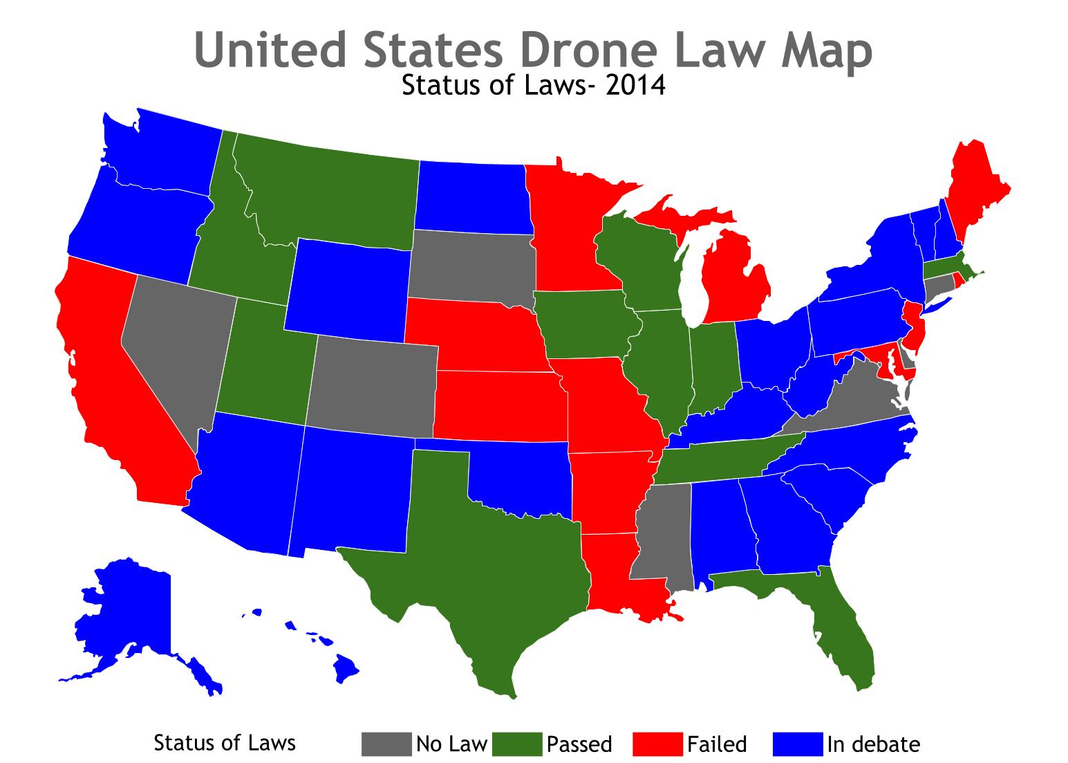
As an operator, I am going to need the laws applying to the drone, bu also laws applying to video, and other data gathered. Can I be filming? What are private / public property data and privacy laws? I am gathering video, weather, temperature, and other crop data over commercial farms, am I allowed to keep it? What are the rules with other types of imaging like infrared? Are there any noise ordinances? There are numerous considerations when flying a drone for both personal and commercial scenarios.
To be an informed pilot I need all this at run(flight)time. I guess I might also need some of it before I head out to my flight location, but also whatever I can also get at flight time. The drone sector seems to begin the process of tackling many of the urgent questions facing the industry. The FAA has stepped up with their guidance, and companies like Airmap are also getting involved with the flight restriction level, as well as weather. We will need the same layer for the legal side of things, helping us receive up to date details on the laws impacting me flying drones, filming, and gathering data–maybe systems to help us manage.
Sounds like another drone API opportunity. I’d say the three top things impacting me when operating my drone(s) right now are 1) flight restrictions 2) weather, and 3) legal. I’m sure if you pulled together the data, provided a simple commercial API, you could do well delivering it to drone application developers and other platforms.